
Georgia, South Carolina, and Florida Brace for Devastating Rainfall from Storm Debby
Tropical Storm Debby, with modest winds, is causing significant damage due to its slow movement and heavy rainfall across Georgia, South Carolina, and Florida. Forecasters predict this week’s rainfall in some areas could be measured in feet. By 8 a.m. ET Tuesday, Debby had slowed to 6 mph, situated about 20 miles southwest of Savannah, Georgia. The storm is expected to cross into the Atlantic Ocean, then veer southwest toward the South Carolina coast.
The National Hurricane Center (NHC) warned of “potentially historic rainfall totals of 10 to 20 inches, with maximum amounts of 25 inches” in parts of Georgia, South Carolina, and North Carolina, posing a catastrophic flooding threat. Florida is also expected to receive several more inches of rain before the storm moves on, with potential flooding extending to the mid-Atlantic and New England through Sunday.
Debby’s predicted path has it moving back ashore just north of Charleston, South Carolina, then veering toward Raleigh and Durham, North Carolina. While it will regain strength over the warm Atlantic waters, it’s not expected to become a hurricane again before its next landfall. The storm is forecasted to reach the South Carolina shore by midday Thursday, staying in the state until Friday.
The NHC predicts a storm surge of 2 to 4 feet from Altamaha Sound, Georgia, to Cape Fear, North Carolina. Nearly 2 million people are also at risk of tornadoes, with a watch issued for a region from Charleston to Wilmington, North Carolina, until 5 p.m. ET Tuesday.
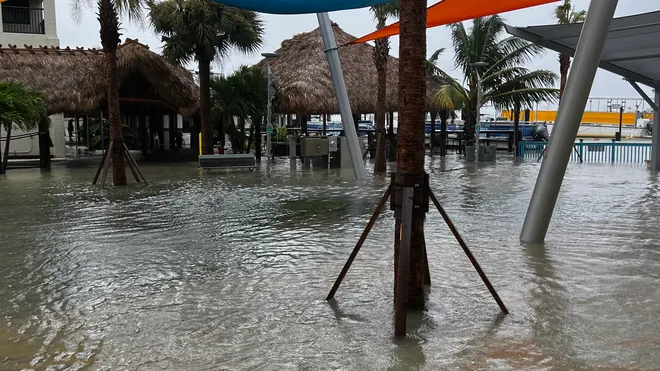
Debby made landfall as a Category 1 hurricane on Florida’s Big Bend coastline, near Steinhatchee, on Monday. The increasing frequency of such storms is linked to climate change, which fuels more powerful cyclones and magnifies their destructive power through rising sea levels and intense rainfall.